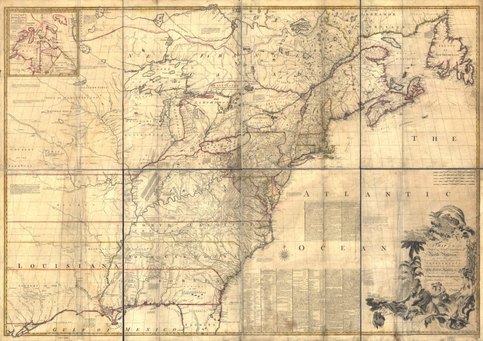
If it hadn’t been for the inaccurate, error-laden Mitchel Map of 1755, a large chunk of northeastern Minnesota—including Duluth and Grand Marais—might have become part of Canada.
So, what was the Mitchell Map, made 270 years ago? At the time, it was the most comprehensive, detailed map of North America. It was created by Virginian-born Dr. John Mitchell, who was neither a geographer nor a mapmaker. He lived in England and drew the map using reports, records, and archives.
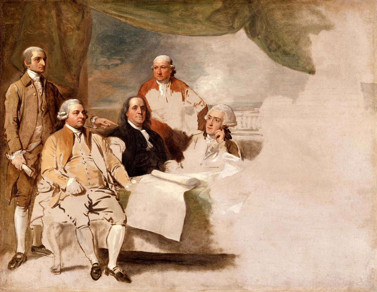
Printed on eight sheets and measuring a whopping 4 feet, 6 inches by 6 feet, 5 inches (136 cm x 195 cm), the Mitchell Map was used by both British and American peace negotiators in developing the Treaty of Paris (1783), which ended the American Revolutionary War (1775-1783) between Great Britain and Britain’s group of Thirteen Colonies, which wanted to break away from British rule and become the United States of America. By this treaty, the U.S. was officially recognized by Britain as a free, sovereign and independent nation.
The Treaty of Paris also attempted to set the boundary lines between the U.S. and eastern part of the future Canada, known then as British North America (BNA). However, early negotiations were somewhat chaotic. One crazy idea suggested by U.S. negotiator Benjamin Franklin was that Britain simply give all of BNA to the U.S. Even more surprising, the British negotiator agreed. However, Great Britain ultimately rejected the idea.
Major problems existed with both the map and treaty. The map had a distorted shape for Lake Superior. An island named “Phelipeaux” didn’t exist. The mysterious Long Lake was nowhere to be found. Locations were inaccurate, and the Lake of the Woods was misshaped. Plus, the language of the treaty was confusing, like which river route was the treaty’s “water communication” to the Lake of the Woods? Or where was the treaty’s “northwesternmost” point on Lake of the Woods? And the Mississippi River—which was to be the treaty’s western boundary of the U.S.—was wrongly shown as being west of the Lake of the Woods.
In his book Minnesota’s Boundary with Canada: Its Evolution Since 1783, author William E. Lass writes, “Had their knowledge of geography been accurate, they would almost certainly have brought the boundary through Lake Superior to the St. Louis River… In effect, the use of Mitchell’s map saved the Mesabi and Vermilion iron ranges for Minnesota…”
It wasn’t until 31 years later, after signing the 1814 Treaty of Ghent that ended the War of 1812 between the U.S. and Great Britain, that a Joint Boundary Commission was established to solve the puzzling boundary issues. One of the British commissioners was the famous fur trader, mapmaker, and astronomer David Thompson, who had already mapped much of Minnesota and Canada for the fur-trading North West Company (NWC).
In his book, Laas writes, “Survey was important because Isle Royale was explicitly named in the peace treaty [Treaty of Paris], which dictated that any boundary through Lake Superior was to stay north of the island…” So, it was that Isle Royale became part of Michigan, even though it was closer to today’s Canada than to Michigan.
The Joint U.S.-British Commission looked at three options for the river route boundary between Lake Superior and Lake of the Woods:
First, the British claimed the boundary river route should be the St. Louis River–Vermillion route, which would have placed much of northeastern Minnesota—including Duluth and Grand Marais—into Canadian territory.
Second, the Americans selected the Kaministiquia River, which pushed the U.S. claim into what is now Ontario, north of today’s Minnesota–Ontario border and near present-day Thunder Bay.
Third, there was the historic fur-trading Grand Portage–Pigeon River route.
It wasn’t until 1842 that the river route boundary was finalized. That’s when the U.S. convinced Great Britain that the Grand Portage–Pigeon River was the correct “water communication” boundary named in the Treaty of Paris. As a result, the Arrowhead Region—including Lake Vermillion, Duluth, and Grand Marais—all became part of the U.S. with the signing of the 1842 Webster-Ashburton Treaty.
But there was still a quirky geographical oddity to figure out. By agreeing on the location of the “northwesternmost” point on Lake of the Woods, a chunk of Minnesota ended up being bordered on three sides by Canada—Manitoba on the west and Ontario to the north and east. By land, this Minnesota area, known as the Northwest Angle, is only accessible by going through Canada first.
How come? Well, the Treaty of Paris, which used the faulty 1755 Mitchell Map, spelled out the boundary edge to be at the “northwesternmost” point on Lake of the Woods. The problem was that the map showed the lake shaped as an oval, when in reality it is a huge lake with multiple bays. It took years to identify the correct location of the point. Once agreed by all, the chunk of U.S. land jutting into Canada became Minnesota’s Northwest Angle.
It’s also worth noting that today’s Canada did not come into existence as one nation until British Parliament passed the British North America Act in 1867. It united the colonies of Ontario, Quebec, Nova Scotia, and New Brunswick into the Dominion of Canada. Today’s Canada consists of 10 provinces and three territories.