The Polar Vortex we endured during the winter of 2013-14 looms large in many people’s memories. Its high snowfall, 95 percent ice cover on Lake Superior, and record low temperatures were followed by an unusually wet spring. That confluence of factors was also the beginning of rising water levels on the Great Lakes, which are currently causing even more newsworthy and memorable weather events.
When temperatures finally rose in the spring of 2014, the immense amounts of water added to Lake Superior were welcomed by the shipping industry. Since the late 1990s, low water levels on the Great Lakes—especially Lakes Michigan and Huron—had impacted the size of loads that ships could carry and distressed the shipping economy. Lake levels bottomed out in 2007 and continued to stay below average for several years.
Then came the Polar Vortex. The lake level rise that began in 2014 has continued; alleviating some shipping woes, but causing its own set of issues. The U.S. Army Corps of Engineers forecast that Lake Superior will rise another 4-5 inches before peaking in August or September, just short of exceeding the all-time recorded lake level from October 1985.
According to Keith Kompoltowicz, chief of the Army Corps’ Watershed Hydrology Branch, the water level rise is a direct result of repeated seasons of wetter than average weather. Precipitation directly over the lake, runoff from snow and rain within the watershed, and evaporation from the lake’s surface all factor into the equation. For perspective, it takes 550 billion gallons to raise the level of Lake Superior by one inch.
Standardized measurements of lake levels began in 1918. At the end of June 2019, Lake Superior was 16 inches higher than the long-term monthly average for June, and 40 inches higher than the record monthly low, set in June 1926. In fact, all of the Great Lakes were sitting above their monthly record highs at the end of June 2019.
The statistics are impressive, but the impacts of high lake levels go beyond just numbers. Waves are creeping inland and lapping at vulnerable shorelines even during the calmest weather. When big storms strike—which they are doing more frequently—they cause significant damage to many of our favorite places along the lakeshore.
The Lakewalk in Duluth, for example, has been torn apart by major storms four times since October 2017, incurring more than $30 million in damages along the way. The city is working on long-term repairs that will prepare the popular bike and pedestrian path to survive even bigger storms in the future.
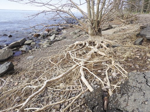
Recently, my bike and I took the detour around the section of the Lakewalk that’s under construction, and continued on to Brighton Beach. This lakeside park just north of Duluth is another popular destination for both locals and tourists. The bedrock slabs jutting out into Lake Superior are less exposed than in the past, but have been relatively unaffected by the storms. Fragile clay banks above and in between the rocks are not so lucky.
In one spot, the newly exposed root networks of ash trees were both artistic and sobering. They’d made a valiant effort to anchor themselves in the soil, but that soil is now gone. Behind them, uneven chunks from the edge of an asphalt parking area were being undercut and carried away by the same forces.
Clay eroding can be a bad thing, but so can clay arriving. Red clay washes out of the shoreline at Brighton Beach and other natural areas, and also enters the lake when flooding rivers carry in big sediment plumes. This hasn’t impacted the spawning habitat of lake trout yet, said Cory Goldsworthy, Lake Superior Area Fisheries Supervisor Minnesota DNR, but a big storm in October and November when trout are reproducing close to shore could bring in sediments that would smother their eggs.
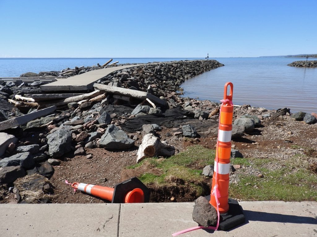
Powerful waves fueled by high water levels pushed around the walkway on top of the breakwall at McQuade Safe Harbor north of Duluth. | EMILY STONE
Toward the east end of Brighton Beach Road, I stopped again to examine a high bank where the waves were slowly undercutting a wide spot in the road commonly used as a pullout. In fact, a City of Duluth truck was parked there, and the driver had crossed the road to examine a culvert. David Kratochwill, I discovered, was a city engineer who’s working on the team that’s trying to find long-term solutions.
“That low spot,” Kratochwill said as he pointed to a place where the road sits right on the lake, “it used to wash out every 10 to 14 years. Now it happens every year or every other year.” He also told me about the city’s hopes to redesign the park for sustainability, extend the Lakewalk out here, and get grant money to help fund it. They’re currently seeking public input, of which, “everyone has strong feelings about their favorite parks,” mused Kratochwill.
Farther up the shore, more of my (and many people’s) favorite places are under siege by the lake. At Split Rock Lighthouse State Park, Luann Udenberg, the Park Manager, told me that a 25-30 foot section of their Hiking Club trail unexpectedly dropped 2 feet straight down earlier this summer. Three years ago a big chunk of one of the cliffs—a place often featured in photos with giant waves crashing—slid down and dropped off. And when winter storms encase shoreline trees in ice, the park experiences quite a bit of damage to vegetation near the campground and elsewhere.
All along the shore, both the Minnesota and Wisconsin DNRs are seeing an increase in requests from private citizens for permits to do erosion control along the shorelines. This often means adding riprap, but also includes more complex erosion control structures.
With so many different but related impacts hitting locations and business all along the shore, I just had to check in on one of my other favorite spots. I’ve spent many evenings bundled up in a wool sweater just so I can enjoy the view from the deck of the Angry Trout restaurant in Grand Marais. Even in a protected harbor, would they be affected by these high water levels?
“We’re definitely worried about it,” admitted Barb LaVigne, one of the owners. “A big blow out of the south would come straight through the breakwall like it was a goalpost.”
One October a few years ago the popular locavore restaurant did experience such a storm, and it blew water up on the deck and under the door. It also wrecked the driveway and sent a fishing boat crashing aground. Even with flood insurance, they’d obviously rather not deal with the headaches.
The extreme weather events that have caused our record high water levels and damaging storms aren’t likely to go away anytime soon, although the water level pendulum may swing the other way. Predictions for the early impacts of climate change include the increased precipitation and the stronger storms that we’ve observed. During the next stage, though, summer temperatures are predicted to rise, and with that the amount of evaporation will increase. Water loss is in the lake’s future.
Standing on the vulnerable, eroding bank at Brighton Beach, I’m struck by a bit of history—geologic history. This fragile clay was deposited in the calm waters at the bottom of a lake. The fact that it’s now exposed to the pounding action of waves is due to a massive episode of climate change.
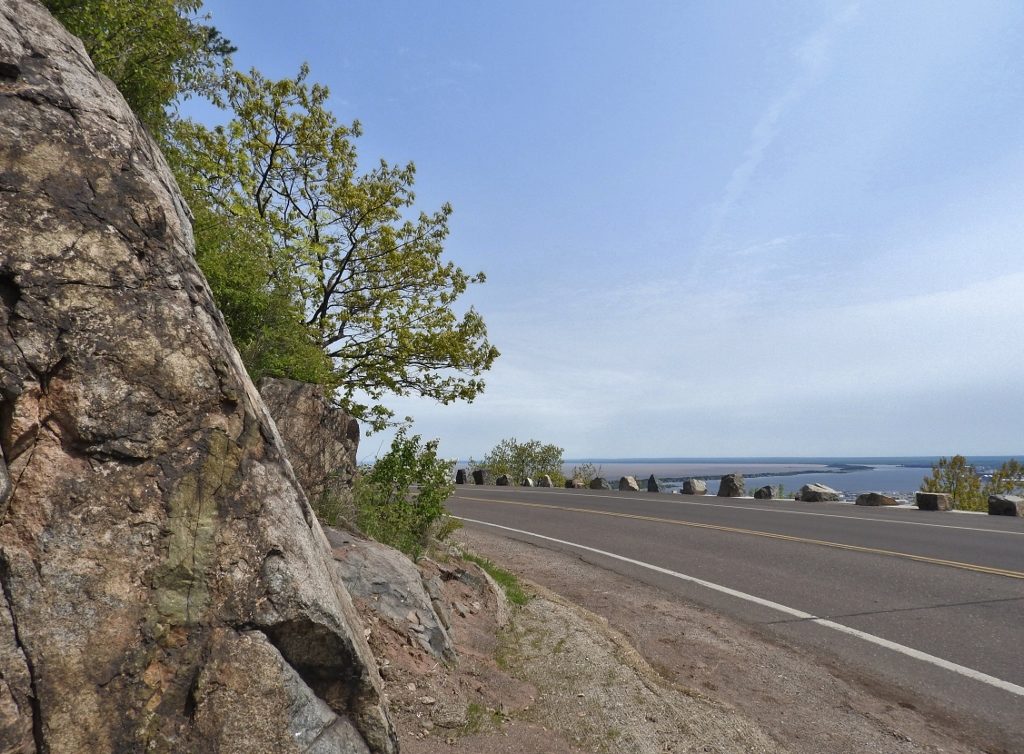
Once upon a time, 11,000 years ago, Glacial Lake Duluth formed from meltwater pouring off the retreating ice sheet. The water pooled in the southwest end of the current Lake Superior basin, but with shorelines 600 feet above the current lake levels. Pounding waves remained at that height long enough to erode wave-cut cliffs and terraces into the solid black bedrock above Duluth. Engineers later took advantage of the landforms to ease construction of Skyline Parkway. Offshore, clay particles settled out and blanketed the land that would become our current shoreline.
As the glaciers melted back even more, lower outlets were exposed, the Great Lakes drained, and eventually they took on a geography that we’d recognize today. Archeological evidence shows that humans were on-hand to watch the changes happening. Recently, Stephen Ballou, a Park Ranger at the Apostle Island National Seashore, told me that Ojibwa Traditional Ecological Knowledge says that islands rose out of the water. With dropping lake levels at the end of the ice age, that’s exactly what it would have looked like.
That gets me wondering, what will our legends be as we witness a changing world? The Polar Vortex of 2013-14 certainly generated its fair share of stories. Now we’re witnessing a lake eat its own shoreline, and storms that fling our roads to the side. Hopefully our narratives will include good decisions by planners who rebuild our infrastructure to withstand the future, ecology and technology that can adapt to the changes, and maybe even concerted efforts to address the root causes of climate change soon enough to prevent weather events that are more than just newsworthy or memorable.