The theme of this issue is “beyond the Northern Wilds,” and looking back over the years, there have been some really cool ‘wild’ places that I’ve visited beyond our region.
One of the most memorable of those wild nature experiences was an up-close look at a massive iceberg in the North Atlantic Ocean, just off shore from Newfoundland’s east coast. The sight of the beautiful, slow-moving sculpture looked like a floating ice cathedral, with an open arch in the middle. And it was amazing to realize I was looking at ancient history, as the glacial ice of icebergs can be more than 10,000 years old.
The iceberg I saw was in a small bay beside the very edge of North America—Cape Spear, the most eastern point of the continent—just 12 km (7.5 miles) from the downtown of the capital city, St. John’s, the most easterly city of North America. Considered to be the Iceberg Capital of the World, it is one of the world’s best places for iceberg viewing from shore.
Icebergs are chunks of freshwater ice that formed on land, with about 90 percent breaking off from glaciers in western Greenland and then making their way south on a route dubbed Iceberg Alley to Newfoundland’s east coast. According to Environment Canada, approximately 10,000 to 40,000 medium- to large-sized icebergs break off annually from about 100 iceberg-producing glaciers, but only 1-2 percent (400-800) make it far enough to be viewed from shore.
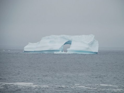
Did you know that icebergs are usually white, not because of snow, but because the ice is full of tiny air bubbles that reflect white light, making the iceberg look white? Some icebergs also show brilliant hues of blue. Icebergs are also categorized by size and shape, ranging from ‘very large’ (over 240 feet high by 670 feet long) to piano-size ‘growlers’ (less than 3 feet high and 16 feet across); the shape of the one I saw was named ‘dry dock.’
According to the Guinness World Records, the largest iceberg ever reliably assessed by satellite imagery was the B15 iceberg, measuring approximately 295 km (183 miles) long, 37 km (23 miles) wide, split (calved) from Antarctica’s Ross Ice Shelf in March 2000—it has since broken up. As of May 13, 2021, the biggest iceberg on earth is A-76 at 170 km (105 miles) long by 25 km (15.5 miles) wide.
After being mesmerized by iceberg watching from shore, I had the bonus of seeing the Cape Spear Lighthouse National Historic Site. Later standing on the windswept rugged bluff of Cape Spear overlooking the North Atlantic Ocean, it was kind of mind-boggling to know there was nothing but ocean waters between Cape Spear and Ireland, the next closest land about 3,154 km (1,960 miles) away. A large Parks Canada sign reminds visitors, “Canada begins here…or ends, depending on which way you are going.”
The lighthouse was first established in 1836, operated continuously until 1955, and was declared a National Historic Site in 1962. Now a famous icon in the province, the site is operated by Parks Canada and has a great system of wooden boardwalks across the grounds, making it easy to get around over the rocks. But, it’s a dangerous coastline. Numerous signs warn visitors to stay on the designated trails, making it clear there is danger if you get too close to the ocean: “Large waves occur WITHOUT WARNING, sweeping the rocks all the way up to the grass! Once you are in the water, strong currents can pull you out to sea beyond rescue…..Obey all warning signs. Never go near the water!” Another sign made clear this was serious stuff, emphasizing people had drowned here after being swept from the rocks by ocean waves.
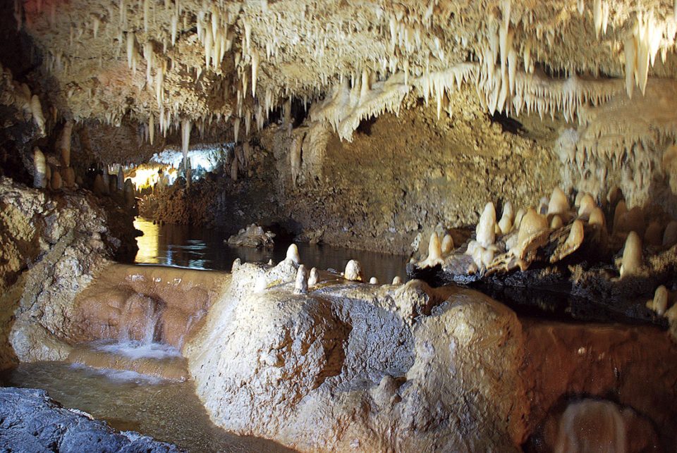
A different kind of wilderness experience was taken underground in the Caribbean. A few years ago in mid-January, while visiting the island of Barbados, I toured the massive underground cave system of the spectacular Harrison’s Cave, a crystalized limestone cave considered ‘alive’ as the stalagmites—rock formations rising from the floor for thousands of years as a result of ceiling drips from the stalactite rock formations hanging from the ceiling—are still growing.
Opened to the public in 1981, an electric-powered guided tram train took us through 2.3 km (1.4 miles) of tunnels connecting these underground caves. We travelled to the dark sections, which lit up as we approached gallery rooms with quirky names like the Great Hall, the Village, the Chapel, the Rotunda and the Altar. There’s also underground flowing streams, lakes and unique waterfalls where the tram stopped so we could walk for a closer view.
I have more ‘beyond the Northern Wilds’ tales to share, like trekking a 5 km round trip through a rainforest on an island off Vancouver Island, convinced Sasquatch was watching us; feeling the powerful energy in the stark beauty of treeless barren lands in the Northwest Territories; and taking a seven-day wilderness kayaking trip and camping on uninhabited islands where cougars and grizzly bears roamed. But, those stories can wait for another time.