Utah’s Watsatch Range is known as a skiing mecca, where a winter’s accumulation of snow may measure 500 inches or more. With major ski areas conveniently located less than an hour from the Salt Lake City Airport, skiing makes a significant contribution to the economy. But in the spring, when the snow melts, the mountain range makes a vital contribution to the people who live there. The runoff feeds seven creeks that are the water supply for the Salt Lake City metropolitan area.
Recently, I spent several days attending the Outdoor Writers of America conference at Snowbird Lodge, high up the Little Cottonwod Canyon. Although the massive ski resort is nestled in the valley, protection of the water quality in Little Cottonwod Creek remains a primary concern. For instance, dogs are not allowed in the valley, because–literally–no one wants to drink doggie doo. However, development pressures, largely driven by the recreation industry, threaten the quality of the water supply and the desires of many people who want accessible places where they can escape from the trappings of civilization. Not everyone wants to take a chairlift or ride a snowmobile to reach the mountaintops. What they want is a wilderness experience.
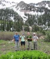
Enter a Utah organization called Save Our Canyons, which came of age during the 1970s at the same time the ski industry was evolving from small, Mom and Pop operations to major resorts. Save Our Canyons has served as a watchdog on development within the Wasatch Range and an advocate for land protection. Since the U.S. Forest Service is the primary landowner, the ultimate land protection is to designate an area as wilderness. One morning, I joined the director of Save Our Canyons, Carl Fisher, and staff from the Washington D.C.-based Pew Campaign for America’s Wilderness on a hike to a proposed wilderness area not far from Snowbird Resort. Carl is a snowboarder who likes to hike into the backcountry and traverse wild slopes, as do many other skiers and boarders. The hiking trail we followed was one of his favorite routes to the high country and an area his organization would like to add to an adjacent, existing wilderness.
The White Pine Trail followed the drainage of a feeder creek into the high country. Due to exceptionally deep snows and a late spring, the creek was a raging torrent. Rivulets of meltwater ran down the trail. Carl said we wouldn’t be able to reach the mountaintops, because we would encounter deep snow at higher elevations. In fact, skiing at Snowbird had just ended on July 4. However, I was less apprehensive about the snow than the the elevation, because our hike began at about 7,500 feet. The trail, an old access road, made a gradual ascent, but we hadn’t gone far before I was perspiring heavily, as if I’d been chopping wood or doing some other strenuous activity. I didn’t feel tired, so somehow the altitude must have made me break into a sweat.

Normally, early July is the best time to see wildflowers, but they hadn’t yet bloomed. The trail passed through a patchy forest spruce and fir, though most of the slopes were bare of trees. Carl said the mountains are home to mule deer, elk, moose, black bears and other wildlife, though big game is scarce near the ski area due to all of the human activity. However, I did add one species to my life list. As we walked past a boulder field, Carl paused. “I heard a pika whistle,” he said and then pointed. “There it is.” The pika is a small rodent that lives in alpine areas. Although it didn’t have stripes, the pika reminded me of a chubby chipmunk. Carl said biologists are concerned climate change may eliminate pika habitat at lower elevations and threaten the existence of this high country rodent. At some point, the pika may be considered for listing as an endangered species.
Although we didn’t see much other wildlife, the White Pine Trail was busy with hikers, even though it was a weekday. During the winter, Carl said the trailhead parking lot is filled with vehicles most days of the week. This isn’t surprising, because Salt Lake City is nearby. In Minnesota, we head for the nearest fishing lake when we want to get outside for a few hours. Out here, folks head for the hills. Eventually, we climbed up to 9,000 feet, where the trees gave way to mountain meadows. Looking down the Little Cottonwood Canyon, we could see the desert basin of the Great Salt Lake. Carl pointed to another mountain range across the basin, where we could see the Kennicot copper mine, an open pit so large it is visible from space. The mine was a complete contrast from our immediate surroundings, which are at risk of other commercial development. At our feet was a patch of leafy green plants called skunk cabbage.
Carl said the plant contains a chemical used in cancer medicine and a pharmaceutical company has proposed mechanized, commercial harvesting in the Wasatch Range. Where we were standing was also being considered for an expansion of the ski area. Wilderness designation would prevent development from occurring. But the most prudent reason for keeping the area wild is doing so protects the source of the water supply for 500,000 people living in the desert below. Salt Lake City is among the fastest growing urban areas in the West.
Walking back down the White Pine Trail, we passed more hikers, including families with children. While we often think of wilderness as distant and inaccessible, here it is available to anyone willing to make a two-hour hike. In an era where we worry people are losing touch with the natural world, it is comforting to know there are still places where you can find wilderness on the edge of town.

