

Are there powerful earth energy points – like in Sedona, Ariz. – right here in our Northern Wilds areas? Did the ancient peoples in Minnesota, Ontario and nearby areas have the knowledge of how to find those energy lines and use them to place their stone circles, burial mounds and sacred sites? And what are the ley lines that some researchers theorize can connect these sites?

My curiosity on the subject came about after a dinner conversation last fall about a man who had identified two powerful energy places in Northwestern Ontario. According to the story, so strong was the man’s belief that he had packed all his belongings in a van and set off to establish his new home in either Dorion (near Nipigon) or Silver Mountain (north of Pigeon River U.S.-Canada border). Unfortunately, no one knew where he ended up.
Ley lines is the term given to alleged alignments that have been found to link prehistoric mounds, stones, sacred sites, temples/churches, and geographical features. Along this grid of straight ley lines can be found burial mounds, effigies, stone structures (standing stones, circles, pyramids, dolmans, Stonehenge, etc.) and megaliths, as well as geographical landmarks such as rivers, waterfalls, ridges and mountains. Ley lines can run for hundreds of miles.
Some researchers see the ley lines as electromagnetic energy paths between powerful points on earth, which connect into a greater earth grid. Could this be a tie-in with the Gaia hypothesis that the whole planet is a living entity? Are these energy lines part of the planet’s pulsating energy?
While the concept of ancient sites along straight alignments was discussed by European researchers back as far as the 1700s, the term “ley line” is credited to England’s Albert Watkins when he used the phrase in seeking and identifying straight lines to ancient sites. He and others became ‘’ley hunters,” travelling and aligning the ancient sites of England and Europe. Later, others tied the lines to energy paths used in the ancient Chinese system of Feng Shui.
Bringing the subject back to our own Northern Wilds, could the ley lines and energy lines apply to our prehistoric mounds, stone structures and landmarks? Were the ancient peoples of America aware of ‘’spirit of place’’ and had the knowledge, now lost, of finding energy lines?
- Stone Alignment: Near the town of Luverne, Minnesota is the Blue Mound State Park with its large quartzite cliffs. At the south end of the park, there is a mysterious perfect line of stones that stretch 1,250 feet in an east-west direction. On the first day of spring and the first day of fall – the two equinoxes – the sunrises and sunsets are lined up perfectly with this stone alignment.
- Stone Circle: A few years ago during a dig at Fort Ridgely State Park, archaeologists from Minnesota Department of Natural Resources discovered an intact, five-foot diameter stone circle, some stones the size of a volleyball, dating back perhaps 2,200 to 7,500 years ago. Who built it and why is still a mystery.
- Effigy Mounds: Stone circles found in Wisconsin’s Medicine Wheel complex are aligned with effigy mounds (animal-shaped earth mounds) located miles away.
- Petroform Site: In Manitoba, a large, nine-acre site exists in the Whiteshell Provincial Park that may be North America’s largest, intact petroform site. It includes human-made boulder outlines, effigies, large carved boulders, stone circles, medicine wheels and rock art. Medicine wheels and petroforms are also found in Manitoba’s Turtle Mountain Provincial Park.
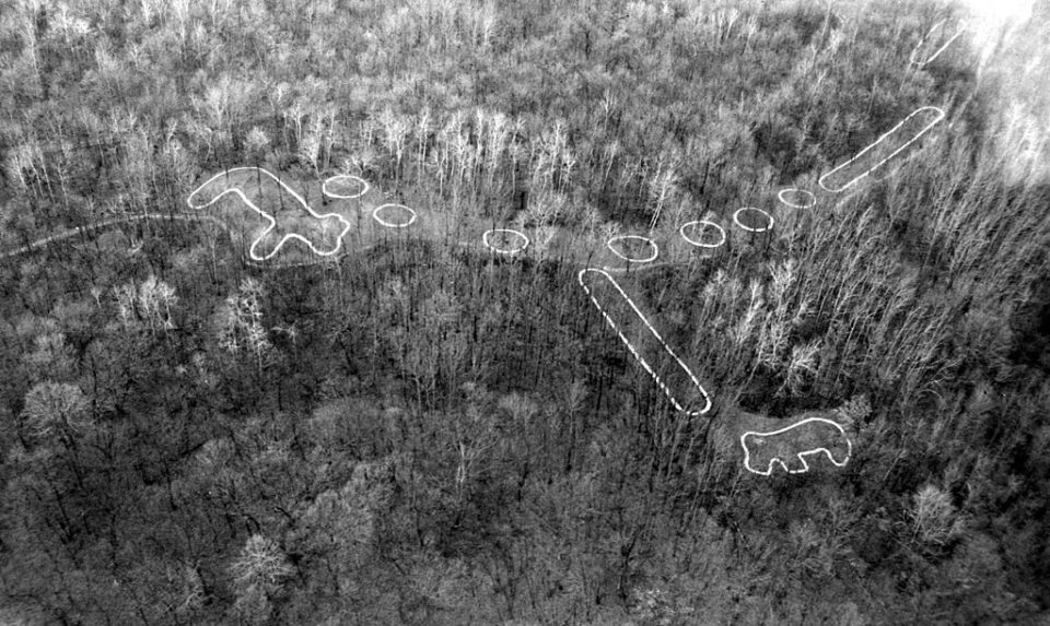
- Intaglios Mounds: Our Northern Wilds area is also home to two of the world’s rare intaglios mounds (animals carved into the ground below natural terrain) – the Turtle Oracle Mound built by Sioux in the 1700s northwest of the town of Deer River, and the 33-foot long Sioux Wild White Dog north of Kakabeka Falls, on a bluff overlooking the Kaministiquia River and Little Dog Lake.
- Ancient Burial Mounds: In both northern Minnesota and northwestern Ontario, there’s the vast network of ancient burial mounds dating back 2000 years, along the Rainy River west of International Falls (all now registered historic sites in both countries). On the Minnesota side of the river is the Grand Mound, the largest burial mound in the upper U.S. Midwest at 325 feet around and 25 feet high, and the McKinstry Mounds (aka Pelland Mounds). Just across the river on the Canadian north side are the 20-25 sacred Manitou Mounds at the Kay-Nay-Chi-Wah-Nung National Historic Site.
Can the sites in Northern Wilds be linked by ley lines? Are they built along energy lines with power points? Could ley hunters connect our sites on earth grids with other world ancient sites? Author Devereaux has written, ‘’…ley hunting is still a young study, held back by prejudice on the part of orthodox archaeologists….ancient people did lay dead straight lines that went over hill and gully for miles, as if the physical obstacles were not there.”
This ‘Strange Tales’ story was originally published in the June-July 2013 issue of Northern Wilds Magazine.
