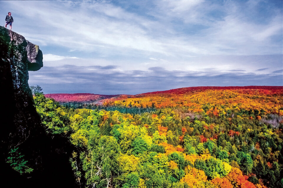
The Superior Hiking Trail®, literally having more ups and downs per mile than most long trails in the U.S., features approximately 80,000 feet of elevation changes in its 300-mile length. The story of how this trail came to be, from nothing at all in 1986 to today’s much-heralded high ranking among the nation’s longest trails, has had many ups and downs, too. This short article sheds light on that history, a remarkable story of intergovernmental agencies and volunteer-based triumph.
Back in 1980, there was a short trail near Tofte, built by the Superior National Forest. It was dubbed the “Superior Trail.” On July 20, 1986, the Minneapolis Star Tribune featured an article headlined “Group proposes 186-mile hiking trail for Lake Superior ridgeline.” Certainly, the author, Dean Rebuffoni, and any number of the people in this group never knew that their theoretical trail, an extension of the original short trail, would expand to 300 miles in length.
The members of the group, called the Superior Hiking Trail Association (SHTA), included Lee Scharr, who worked at the Tofte U.S. Forest Service ranger station. He wrote a Clemson University thesis paper that suggested the feasibility of building a long trail crossing multiple jurisdictions—an unheard-of notion in Minnesota at the time. The challenge the association accepted was to coordinate various land management agencies, primarily the Minnesota DNR State Parks Division and Superior National Forest, state forests, and counties, plus many small private landowners with the help of volunteers from the hiking community, to endorse and then build a new footpath. It would follow the Lake Superior first ridgeline, encompassing tremendous views of both the big lake and smaller interior lakes; connect seven state parks; cross dozens of streams slicing through canyons and tumbling over waterfalls; and ultimately be finished in just a few years. In 1986, Scharr stated, “When this trail is completed, in approximately four years, its future will rest on the ability of volunteers to maintain its entire 200-mile length.”
Thirty-one years later, in 2017, the trail was “finished,” linking not only those seven state parks but also an eighth park, Jay Cooke State Park. It passed through a major city, Duluth, and extended 300 miles, from Wisconsin to Canada.

The first order of business in 1986 was for the association to hire someone to oversee the process. Fresh off his stint as the DNR’s builder of the North Shore State Trail, a snowmobile trail, Tom Peterson was the logical choice. He knew the North Shore terrain better than anyone. Years later, Peterson fondly remembered, “I was in the right place at the right time. It was a dream job. I got paid to walk around in the woods. I actually worked for two bosses, the SHTA and the DNR. In effect that made me the boss. I pretty much wrote my own job description.”
His salary was paid thanks to the newly formed SHTA, which requested and received grant money from the Legislative Commission on Minnesota Resources (LCMR). The commission allocated funds to various state agencies from a large pool of cigarette tax and lottery proceeds. At the time, the SHTA needed to convince the commission that the money would be well spent on an environmental awareness cause. No new, untested non-profit organization had ever asked for such a grant. But as John Velin, the LCMR director, later confided, “It was a slam dunk; we loved that project.”
Peterson wandered the hills with a topo map, a compass, and a pencil. Modern mapping tools like GPS did not exist. He drew lines on his maps, and as Anne McKinsey, an early SHTA board member and president, wrote, “Tom’s insistence on finding the best river crossing, the most satisfying falls or canyon view, the most ancient tree, the coolest cedar grove, and the most interesting geological feature, is evident in every step of the trail.”
Of course, Peterson did not build the trail alone. Right away, he took advantage of the state’s Minnesota Conservation Corps (MCC). Crews of young adults carved the trail out of the wilderness. They were paid minimum wage but loved the work; for many of them it was a stepping stone leading to professions in nature and the outdoors. Peterson also availed himself of a sordid situation in Silver Bay. Reserve Mining had shut down the taconite processing plant, and laid-off mine workers were looking for ways to make ends meet. Peterson’s “veteran crew” were all elderly in age, but hardworking. “I loved those old guys,” he quipped, adding that they could outperform the much younger, more able-bodied MCC crews.
For many years, the highs far exceeded the lows in the trail-building experience. When Peterson appeared at SHTA board meetings he always had the same story: “That section we built last week is the best one yet.” Every step of the trail was a great story, led to phenomenal views, and became an instant hiker favorite.
By 1993, the LCMR money well ran dry and Peterson went on to build the Mesabi Range Trail.

SHTA volunteers were then the principal trail builders and maintainers of the Superior Hiking Trail. Select, smaller grants helped along the way when professional labor was needed. The trail has been divided into 83 separate segments, each with its own volunteer maintenance person or group. Contracted experts coordinate hundreds of volunteers on many projects each year. Individual campsites are adopted by volunteers, as are the trailhead parking areas. Volunteers are key—the 300-mile trail may be “finished” but the work is never done.
Today, the SHTA is very lucky to have financial assistance from the LCCMR (the extra C is for Citizen’s) and many other benevolent grant-donating sources. Within state parks and the Superior National Forest, much labor and many materials are covered by these grants.
However, despite a mostly rosy picture of the past, there are also stories of woe. In the immediate Grand Marais area, several come to mind. The Superior Hiking Trail was initially allowed to utilize the pre-existing Pincushion Mountain Cross Country Ski Area trails—a bad idea! Winter walkers were ruining the groomed trails. That experience was eventually overcome when the SHTA hired Dirt Candy, the Grand Marais-based trail-building team of Adam and Mica Harju. With a variety of grant monies and help from the local North Superior Ski and Run Club, a wonderful reroute was built in 2020. The area traversed was wet and necessitated an extensive boardwalk, but the result is beautiful.

Another Grand Marais lowlight was the exceptionally hard task of building the bridge over the Devil Track River. This is Peterson’s favorite story to retell. The very heavy and large timbers had to be dropped down into the canyon manually. Then, they had to be lifted high to create the A-frame structure. No one knew how to do it! So, as Peterson’s story goes, “I found an old guy, can’t remember his name, never seen him since—Finnish, I think, a long-retired farmer/logger.” His expertise in ‘old school’ coaxing of gear and weird contraptions that Peterson could not even pronounce did the trick. The bridge is now a highlight of the trail.
Yet another Devil Track River story is worth telling. Peterson felt lucky to get permission to cross a critical piece of privately owned land at the bottom of the canyon. It was a ‘crux move;’ the only way up and out of the canyon was on this land. All was well until the owner wanted to sell. He did not want the SHTA lease to hamper a buyer’s motivation to step in. Thankfully, the Parks and Trails Council of Minnesota (PTCM) saved the day. This member-based organization is responsible for many additions to parks and trails throughout the state. They buy land, transfer ownership to DNR parks and trails, and thus recoup their expenses. The pool of money can then be used for the next big project. Land transactions can easily exceed one million dollars. This transaction was small in comparison to most others, but in this case, there was no state park nearby to sell the land to, so there was no way to recoup the expense. Nonetheless, PTCM bought the property with help from a fundraising effort by the SHTA. PTCM still owns the land, so the trail easement is secure.
Another story of interest to current hikers might be the “lost” Superior Hiking Trail segments. The trail formerly went to the top of a downhill ski area in Grand Marais, to Mount Josephine, directly into Two Harbors, and into Gooseberry Falls State Park (although as of last year, the main trail no longer enters the park). It is an interesting story.
As mentioned before, today, volunteers are key to the trail’s success. You can find a list of volunteer work projects online at: superiorhiking.org. Helpers of all abilities are welcome, so don’t be shy. The SHTA publishes a guidebook, trail atlas maps, and a trail data book.

For more stories that relate the ups and downs of the Superior Hiking Trail, you can read my book, The Superior Hiking Trail Story, The Trek Continues. It includes over 350 color photos and hundreds of trail register hiker quotations. The book is available at many stores along the North Shore, as well as from the Superior Hiking Trail Association and my website: northshorephotoart.com.
Use of the registered trademark ‘Superior Hiking Trail’ name has been permitted by the Superior Hiking Trail Association.